Piloting a Boat Through French Canals:
Where To Go — Selecting a Canal and Logs of Our Trips
Where to go — selecting a canal
So you have decided that you want to travel through France on a rented canal boat. Now you need to decide which canal to explore! You have many choices, and the canals and the areas they pass through differ.
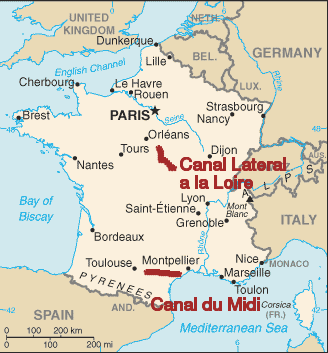
We have now done this three times. Our first trip was on the Canal Latéral à la Loire from Briare to Decize, and we returned to that route for the third trip.
Our second trip was on the Canal du Midi from Port Cassafieres (just east of Briare) to Castelnaudary. But when you start looking into this you realize that France has many canals.
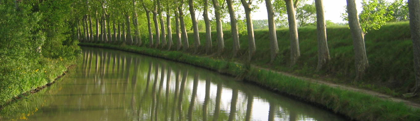
The Canal du Midi is the most popular route, but that's both good and bad. It's good because it's popular for a reason — fantastic scenery, plenty of interesting sights and great places to stop along the way. The down side is the popularity itself. It could be rather crowded during the high season. The Canal du Midi has a lot of locks, so even when traffic is relatively low you spent quite a bit of time on some days just going through locks. If you have to wait for boats ahead of you to clear the lock, it can take quite a while.
Another consideration is the lock design. The locks in the Canal Latéral à la Loire are rectangular, and so you can simply pilot the boat into the lock and have at least one person step off onto one of the ladders in the canal walls to climb up and handle ropes.
However, the locks in the Canal du Midi are oval. While there are still ladders in the canal walls, you cannot step onto them off the boat. You must put at least one person ashore before entering the lock so they can run ahead and handle the ropes. The Canal du Midi also has a larger number of locks as shown below.
I am very happy to have done both of these trips, and I feel that we were fortunate in the order in which we did them. If you are considering your first canal boat trip, I would strongly advise that you carefully consider the number of locks and distance per day when planning your trip. On our first trip we went through 23 locks during the week. On the second trip we went through 20 locks on the last day alone. We would have felt rather overwhelmed if that had been our first canal trip.
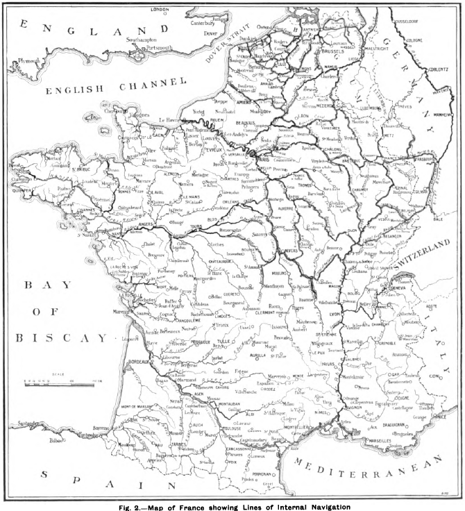
Map of the inland waterways in France. From Traction and Transmission, Vol IV, May-August 1902, London.
Map of the Canal du Midi.
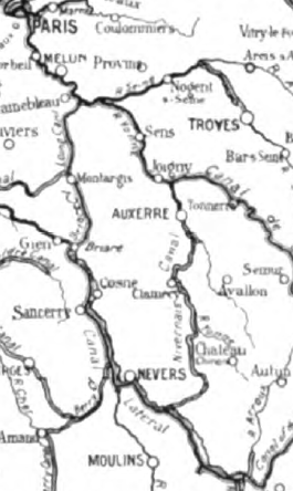
Map of the Loire River and the Canal Lateral à la Loire.
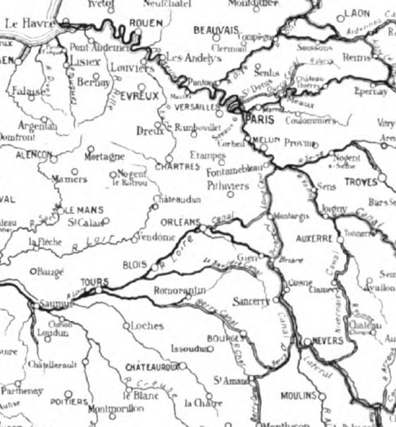
Map of the Seine River, Loire River and the Canal Lateral à a Loire.
Amazon
ASIN: 2741601704
Amazon
ASIN: 274160164X
Canal atlases such as the following are extremely useful references if you can find them at reasonable prices. These have nicely detailed maps of the canal itself showing the location and height of locks, nearby roads and towns, and even locations of restaurants, grocery stores, water supply, fuel, waste pumping, and more.
Amazon 1846234883
Amazon 1846230144
Some used book dealers selling through Amazon might have good prices on these. Some titles will be very expensive through Amazon, but should be much more reasonable through a French or even British book dealer. Or contact Grafocarte directly.
Navicarte Carte-Guide de Navigation Fluviale
Éditions Grafocarte
125 rue Jean-Jacques Rousseau
BP 40
92132 Issy-Les-Moulineaux
www.grafocarte.fr
ISBN for Canal du Midi, volume 11 in this series, is
2-916919-09-0 and 978-2-916919-09-6.
I purchased this at
Stanford's
great travel book store in London.
Guide Fluvial
Éditions du Briel
11400 Castelnaudary
ISBN for Bourgogne and Nivernais,
volume 2 in this other series, is
2-913120-00-8.
Amazon
ASIN: 0852880642
Below are logs of our two trips. Note that there may be multiple systems of kilometer measurement along the canal with differing start points, I have used what was used in the canal atlases mentioned above. Entirely different kilometerage systems are used for both canals in the book Inland Waterways of France by E.E. Benest, first published in 1956, 3rd edition in 1971.
|
Canal Latéral à la Loire
from Briare
south (ascending)
to Decize
130 kilometers, 23 locks, 54.2 meter elevation gain |
|||||
| Day | km | Location | Elevation Gain | Total Elevation | Notes |
| 1 | 198.0 | Briare | — | 0 m | Start. You are promised that your boat will be available by 1600, but it may be available earlier, maybe around 1300-1400, if it was clean after the previous rental. |
| 197.5 | Briare | — | 0 m | You cross the Briare Canal Bridge, built in 1820-1838 to carry the canal across the Loire River. | |
| 184.4 | Beaulieu | — | 0 m | Stopped for the night at
Beaulieu, a small town with one
restaurant on the central square. 13.6 km, no locks or elevation gain. |
|
| Day | km | Location | Elevation Gain | Total Elevation | Notes |
| 2 | 184.4 | Beaulieu | — | 0 m | Start of day 2. |
| 182.4 | Lock #38 | 2.10 m | 2.10 m | — | |
| 180.5 | Belleville-sur-Loire and Lock #37 | 2.00 m | 4.10 m | Explored Belleville-sur-Loire on foot before going through the lock as it was closed when we arrived. | |
| 174.5 | les Houards and Lock #36 | 1.80 m | 5.90 m | ||
| 169.6 | Lock #35 | 2.10 m | 8.00 m | ||
| 165.6 | Lock #34 | 3.00 m | 11.00 m | ||
| 159.5 | St-Thibault | — | 11.00 m | Stopped for the night at
St-Thibault, a relatively larger town
paired with St-Satur across the canal
with several restaurants. 24.9 km, 5 locks, 11.0 meter elevation gain |
|
| Day | km | Location | Elevation Gain | Total Elevation | Notes |
| 3 | 159.5 | St-Thibault | — | 11.00 m | Start of day 3. |
| 156.2 | Lock #33 | 3.80 m | 14.80 m | ||
| 150.9 | Lock #32 | 1.70 m | 16.50 m | ||
| 146.0 | Lock #31 | 2.00 m | 18.50 m | ||
| 143.1 | Herry | — | 18.50 m | Stopped for the night at
Herry, a nice small town overlooking
the canal. 16.4 km, 3 locks, 8.5 meter elevation gain. |
|
| Day | km | Location | Elevation Gain | Total Elevation | Notes |
| 4 | 143.1 | Herry | — | 18.50 m | Start of day 4. |
| 143.0 | Lock #30 | 2.70 m | 21.20 m | ||
| 135.6 | Lock #29 | 2.00 m | 23.20 m | ||
| 133.0 | Lock #28 | 2.60 m | 25.80 m | ||
| 128.4 | Lock #27 | 2.5 m | 28.30 m | ||
| 125.8 | Lock #26 | 2.5 m | 30.80 m | ||
| 125.5 | Lock #25 | 2.5 m | 33.30 m | ||
| 125.0 | Marseilles-lès-Aubigny | — | 33.30 m | Had considered stopping for the night at Marseilles-lès-Aubigny but continued on as it was full and rather industrial. | |
| 120.1 | Cours-les-Barres | — | 33.30 m | Stopped for the night at
Cours-les-Barres, a much better
place to stay than
Marseilles-lès-Aubigny.
Another small town overlooking the
canal with one restaurant. 23.0 km, 6 locks, 14.8 meter elevation gain |
|
| Day | km | Location | Elevation Gain | Total Elevation | Notes |
| 5 | 120.1 | Cours-les-Barres | — | 33.30 m | Start of day 5. |
| 118.5 | les Mahauts | — | 33.30 m | Continue straight ahead, not taking the embranchement de Givry to the left leading down to the Loire. | |
| 116.1 | Lock #24 | 1.4 m | 34.70 m | There is no Lock #23. | |
| 111.5 | Pont des Caillettes | — | 34.70 m | Turn about 45° to left rather than continuing straight into unmaintained old branch of the canal. | |
| 110.5 | Pont des Caillettes | — | 34.70 m | Tied up and got a great meal at the old Inn here. | |
| 110.4 | Locks #21-22 | 9.20 m | 43.90 m | Double lock, both rather high. | |
| 110.1 | Pont-canal du Guétin | — | 43.90 m | Cross the Allier River, a tributary of the Loire, on a Guétin Canal Bridge. Immediately beyond, through km 109, carefully stay within the channel marked with buoys to avoid shallows. | |
| 102.2 | Plagny | — | 43.90 m | Stopped for the night at
Plagny.
Walk north just over one kilometer
along the N7 to find a large
supermarket.
Continue north on N7 into St-Antoine
and toward Nevers to find a pharmacy
and pretty much anything else you
might need. 17.9 km, 3 locks, 10.6 meter elevation gain |
|
| Day | km | Location | Elevation Gain | Total Elevation | Notes |
| 6 | 102.2 | Plagny | — | 43.90 m | Start of day 6. |
| 100.3 | — | 43.90 m | Continue straight ahead, not taking the embranchement de Nevers to the left leading down to the Loire. | ||
| 93.3 | Chevenon | — | 43.90 m | Walked into the small town of Chevenon. Got lunch at the cafe, saw the chateau. | |
| 89.5 | Lock #20 | 1.20 m | 45.10 m | ||
| 85.7 | Lock #19 | 3.90 m | 49.00 m | ||
| 80.5 | Fleury-sur-Loire | — | 49.00 m | Stopped for the night at Fleury-sur-Loire. | |
| Day | km | Location | Elevation Gain | Total Elevation | Notes |
| 7 | 80.5 | Fleury-sur-Loire | — | 49.00 m | Start of day 7. |
| 80.4 | Lock #18 | 1.80 | 50.80 m | ||
| 76.0 | Lock #17 | 3.70 | 54.50 m | ||
| 75.0 | Lock #16 | 1.70 | 56.20 m | ||
| 68.4 | Decize | -2.00 | 54.20 m | Turn to left off canal, descending through a lock into a basin that leads, via another lock, toward the Loire River and the Canal du Nivernais. | |
| 68.0 | Decize | 54.20 m | Finished our trip at
Decize. 12.5 km, 3 locks, 5.2 meter net elevation gain |
||
Compared to the Canal du Midi, the Canal Latéral à la Loire is more level and so with far fewer locks, and the section we traveled passes through more villages and through fewer larger towns.
|
Canal du Midi,
from Port Cassafieres
west (ascending)
to Castelnaudary
157.1 kilometers, 62 locks, 167.56 meter elevation gain |
|||||
| Day | km | Location | Elevation Gain | Total Elevation | Notes |
| 1 | 222.5 | Port Cassafieres | — | 0 m | Start. You are promised that your boat will be available by 1600, but it may be available earlier, maybe around 1300-1400, if it was clean after the previous rental. |
| 218.3 | Lock | 2.23 m | 2.23 m | ||
| 213.8 | Lock | 1.95 m | 4.18 m | ||
| 212.5 | Lock | 2.26 m | 6.44 m | ||
| 209.5 | Béziers | — | 6.44 m | Stopped for the night
at Béziers, just below
the boat basin. 13.0 km, 3 locks, 6.44 meter elevation gain |
|
| Day | km | Location | Elevation Gain | Total Elevation | Notes |
| 2 | 209.5 | Béziers | — | 6.44 m | Start of day 2. |
| 208.4 | Lock | 4.24 m | 10.68 m | ||
| 208.0 | Lock | 6.19 m | 16.87 m | ||
| 206.5 | Locks (7) | 13.6 m | 30.47 m | This seven-stage flight of locks is one of the tourist attractions of Béziers. The flight operates going up only for certain hours and going down only for other hours. Make sure you understand the schedule and you get into what will probably be a long line in time to get through by when it shuts down around 1600! If you are traveling to the west, ascending the canal, the next lock is 54 kilometers and about a day and a half away. | |
| 200.5 | Colombiers | — | 30.47 m | Stopped for the night at
Colombiers.
Nice marina at a small town,
with a fancy restaurant, a pizza
place, a patisserie
and a supermarket right at the
marina. 9.0 km, 9 locks (1, 1, 7), 24.03 meter elevation gain |
|
| Day | km | Location | Elevation Gain | Total Elevation | Notes |
| 3 | 200.5 | Colombiers | — | 30.47 m | Start of day 3. |
| 194.5 | Poilhes | — | 30.47 m | Stopped to explore the village. | |
| 188.4 | Capestang | — | 30.47 m | Stopped to explore the town, got a late lunch at a pizza place. | |
| 166.0 | le Somail | — | 30.47 m | Stopped for the night
at le Somail.
Very nice small town with one of the
original inns used by travelers in
the early years of the canal.
No supermarket, but there is a market
boat selling food and drinks, open
until about 1700.
A small restaurant and cafe right on
the canal. 34.5 km, no locks or elevation gain |
|
| Day | km | Location | Elevation Gain | Total Elevation | Notes |
| 4 | 166.0 | le Somail | — | 30.47 m | Start of day 4. |
| 161.0 | Ventenac en Minervois | — | 30.47 m | Stopped to explore the town, bought wine at the winery. | |
| 152.3 | Lock | 2.41 m | 32.88 m | The first lock after 54 km of flat water. | |
| 149.8 | Locks | 4.63 m | 37.51 m | Two-stage lock | |
| 147.1 | Locks | 5.81 m | 43.32 m | Two-stage lock | |
| 146.4 | Lock | 3.14 m | 46.46 m | ||
| 142.7 | Lock | 3.62 m | 50.08 m | ||
| 139.0 | Laredorte | — | 50.08 m | Stopped for the night at
Laredorte. A nice larger town lying
to one side of the canal,
so you are at its edge rather than
in the center.
Several stores within walking
distance.
A nice restaurant right on
the canal. 27.0 km, 7 locks (1,2,2,1,1), 19.61 meter elevation gain |
|
| Day | km | Location | Elevation Gain | Total Elevation | Notes |
| 5 | 139.0 | Laredorte | — | 50.08 m | Start of day 5. |
| 136.4 | Locks | 4.63 m | 54.71 m | Two-stage lock | |
| 133.6 | Locks | 5.47 m | 60.18 m | Two-stage lock | |
| 131.6 | Locks | 5.61 m | 65.79 m | Two-stage lock | |
| 130.4 | Locks | 8.73 m | 74.52 m | Three-stage lock | |
| 127.2 | Lock | 3.70 m | 78.22 m | ||
| 122.4 | Millegrand | — | 78.22 m | Stopped to explore the village | |
| 118.0 | Locks | 7.84 m | 86.06 m | Three-stage lock | |
| 117.5 | Trèbes | — | 86.06 m | Stopped for the night
at Trèbes.
A larger town,
several stores and restaurants. 21.5 km, 13 locks (2,2,2,3,1,3), 35.98 meter elevation gain |
|
| Day | km | Location | Elevation Gain | Total Elevation | Notes |
| 6 | 117.5 | Trèbes | — | 86.06 m | Start of day 6. |
| 113.4 | Lock | 2.77 m | 88.83 m | ||
| 112.6 | Lock | 3.24 m | 92.07 m | ||
| 109.0 | Lock | 2.48 m | 94.55 m | ||
| 108.8 | Locks | 6.71 m | 101.26 m | Two-stage lock | |
| 105.6 | Carcassonne | — | 101.26 m | Stopped to get lunch and explore the walled city of Carcassonne, a UNESCO World Heritage Site. You need to allow plenty of time to visit Carcassonne, and so you must plan your stops so this day covers relatively little distance. The close spacing of locks on this section of the canal coupled with their limited operating hours requires careful planning. | |
| 105.3 | Lock | 2.66 m | 103.92 m | ||
| 99.9 | Lock | 2.66 m | 106.58 m | ||
| 98.5 | Lock | 3.90 m | 110.48 m | ||
| 98.2 | Locks | 5.82 m | 116.30 m | Two-stage lock | |
| 94.3 | Sauzens | — | 116.30 m | Stopped for the night at
Sauzens.
Just a small village, no market,
store or restaurant. 23.2 km, 10 locks (1,1,1,2,1,1,1,2), 30.24 meter elevation gain |
|
| Day | km | Location | Elevation Gain | Total Elevation | Notes |
| 7 | 94.3 | Sauzens | — | 116.30 m | Start of day 7. |
| 93.4 | Lock | 2.47 m | 118.77 m | ||
| 85.9 | Lock | 2.35 m | 121.12 m | ||
| 80.3 | Lock | 3.00 m | 124.12 m | ||
| 79.0 | Lock | 2.14 m | 126.26 m | ||
| 77.4 | Lock | 3.05 m | 129.31 m | ||
| 73.6 | Lock | 3.15 m | 132.46 m | ||
| 72.2 | Lock | 3.52 m | 135.98 m | ||
| 71.7 | Lock | 2.02 m | 138.00 m | ||
| 70.7 | Lock | 2.40 m | 140.40 m | ||
| 69.7 | Lock | 2.48 m | 142.88 m | ||
| 69.1 | Lock | 2.82 m | 145.70 m | ||
| 68.7 | Locks | 7.22 m | 152.92 m | Three-stage lock | |
| 67.1 | Locks | 5.22 m | 158.14 m | Two-stage lock | |
| 65.6 | Locks | 9.42 m | 167.56 m | Four-stage lock | |
| 65.4 | Castelnaudary | — | 167.56 m | Finished our trip at the
large basin at Castelnaudary. 28.7 km, 20 locks (1,1,1,1,1,1,1,1,1,1,1,3,2,4), 51.26 meter elevation gain |
|
As for Thomas Jefferson's 1787 trip through southern France and along the Canal du Midi, called the Canal du Languedoc in his day, here are some notes he made:
May 14 BEZIERES — Rich plains in corn [meaning "grain" in Europe]. St foin and pasture; hills at a little distance to the right in olives, the soil both of hill and plain is red, going from Agde to Bezieres. But at Bezieres the country becomes hilly, and is in olives, corn, St. foin, pasture, some vines and mulberries.
May 15 BEZIERES, ARGILIES, LE SAUMAL — From Argilies to Saumal are considerable plantations of vines. Those on the red hills to the right are said to produce good wine. No wood, no enclosures. There are sheep and good cattle. The Pyrenees are covered with snow. I am told they are so in certain parts all the year. The Canal of Languedoc along which I now travel is 6 toises wide at bottom, and 10 toises at the surface of the water, which is 1 toise deep. The barks which navigate it are 70 and 80 feet long, and 17 or 18 feet wide. They are drawn by one horse, and worked by 2 hands, one of which is generally a woman. The locks are mostly kept by women, but the necessary operations are much too laborious for them. The encroachments by the men on the offices proper for the women is a great derangement in the order of things. Men are shoemakers, tailors, upholsterers, staymakers, mantua makers, cooks, doorkeepers, housekeepers, housecleaners, bedmakers. The coëffe the ladies, and bring them to bed: the women therefore, to live are obligated to undertake the offices which they abandon. They become porters, carters, reapers, wood cutters, lock keepers, smiters on the anvil, cultivators of the earth &tc. Can we wonder if such of them as have a little beauty prefer easier courses to get their livelihood, as long as that beauty lasts? Ladies who employ men in the offices which should be reserved for their sex, are they not bawds in effect? For every man whom they thus employ, some girl, whose place he has taken, is driven to whoredom. The passage of the eight locks at Bezieres, that is from the opening of the first to the last gate, took 1 hours 33 minutes. The bark in which I go i drawn by one horse, and goes from 2 to 3 geographical miles an hour. The canal yields abundance of carp and eel. I see also small fish resembling our perch and chub. Some plants of white clover, and some of yellow on the banks of the canal near Capestang; Santolina also and a great deal of a yellow iris. Met a raft of about 350 beams 40 feet long and 12 or 15 inches in diameter, formed into 14 rafts tacked together. The extensive and numerous fields of St. Foin, in general bloom, are beautiful.
May 16 LE SAUMAL, MARSEILLETTE. May 17 MARSEILLETTE. CARCASSONNE — From Saumal to Carcassonne we have always the river Aube close on our left. This river runs in the valley between the Cevennes and Pyrenees, serving as the common receptacle for both their waters. It is from 50 to 150 yards wide, always rapid, rock, and insusceptible of navigation. The canal passes in the side of the hills made by that river, overlooks the river itself, and its plains, and has its prospect ultimately terminated, on one side by mountains of rock overtopped by the Pyrenees, on the other by small mountains, sometimes of rock, sometimes of soil overtopped by the Cevennes. Marseillette is on a ridge which separates the river Aube from the Etang de Marseillette. The canal, in its approach to this village, passes the ridge, and rides along the front overlooking the etang and the plains on its border; and having passed the villages recrosses the ridge and resumes its general ground in front of the Aube. The growth is corn, St. foin, pasture, vines, mulberries, willows, and olives.
May 18 CARCASSONNE. CASTELNAUDARI — Opposite to Carcassonne the canal receives the river Fresquel, about 30 yards wide, which is its substantial supply of water from hence to Bezieres. From Bezieres to Agde the river Orb furnishes it, and the Eraut from Agde to the Etang de Thau. By means of the ecluse ronde at Agde ["ecluse" meaning "lock"] the waters of the Eraut can be thrown toward Bezieres to aid those of the Orb as far as the ecluse de Porcaraigne, 9 geometrical miles. Where the Fresquel enters the canal there is, on the opposite side, a waste, to let off the superfluous waters. The horse-way is continued over this waste by a bridge of stone of 18 arches. I observe them fishing in the canal with a skimming net of about 15 feet diameter, with which they tell me they catch carp. Flax in blossom. Neither strawberries nor peas yet at Carcassonne. The Windsor bean just come to table. From the Ecluse de la Lande we see the last olive trees near a metairee or farmhouse called le Lande. On a review of what I have seen and heard of this tree, the following seems to be its Northern limits. Beginning on the Atlantic, at the Pyrenees, and along them to the meridian of la Lande, or of Carcassonne up that Meridian to the Cevennes, as they begin just there to raise themselves high enough to afford it shelter. Along the Cevennes to the parallel of 45° latitude, and along that parallel (crossing the Rhone near the mouth of the Isere) to the Alps, thence along the Alps and the Appenines to what parallel of latitude I know not. Yet here the tracing of the line becomes the most interesting. For from the Atlantic so far, we see this production the effect of shelter and latitude combined. But where does it venture to launch forth, unprotected by shelter, and by the mere force of latitude alone? Where for instance does its northern limit cross the Adriatic? — I learn that the olive tree resists cold to 8° of Reaumur below the freezing point, which corresponds to 14° above zero of Farenheit, and that the orange resists to 4° below freezing of Reaumur, which is 23° above zero of Farenheit.