Travel > UK > Oban
Ferry and Mull
The Isle of Iona
A Hebrides ferry leaves Oban.

By Ferry (and Bus) from Oban to Iona

                    
Oban is at the west end of the A85 highway, running east to Perth, and connects to the northeast via the A828 to the A82 running through Fort William and on up the Great Glen to Inverness on the North Sea coast. There is frequent bus service northwest to Fort William, connecting beyond there to Inverness and other destinations, and bus service south as far as Glasgow. Oban is the terminus of a rail line from Glasgow. There are about three trains in each direction every day between Oban and Glasgow.

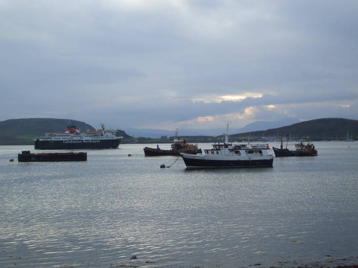
But the distinctive transport of Oban is its frequent ferry service connecting the west coast of Scotland to the Inner and Outer Hebrides. Caledonian MacBrayne is the major ferry operator, and Oban is their busiest terminal.

Above you see a Caledonian MacBrayne ferry leaving Oban harbor in the evening, bound for Craignure on Mull and beyond. That's the island of Kerrera directly across from Oban harbor, and in the distance between the two hills of Kerrera you can see the island of Mull in the distance.

U.S. government chart of the northwest coast of Scotland including the Inner Hebrides, Mull and Iona.

U.S. government chart showing Iona, Mull, and Oban.

I got to Iona by simply buying my tickets along the way. The stages are:

Caledonian MacBrayne promotes a package, a combination ticket including all three stages in both directions on one day. But I found that I could simply buy each ticket as I went (day return for Oban-Craignure, singles for the other links) for a total of only about 60% the price of the package!
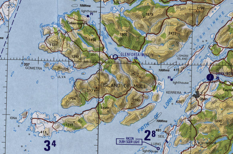
On board the ferry from Oban to Iona, crossing the Firth of Lorn and Loch Linnhe, passing Eilean Musdile and the Isle of Lismore.

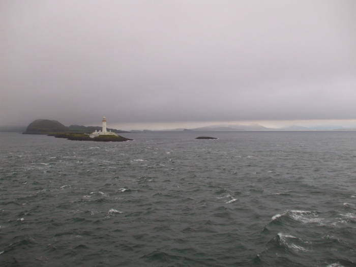
The ferry crosses the Firth of Lorn and the open end of Loch Linnhe. Here's we're passing the lighthouse on Eilean Musdile off the southern tip of the Isle of Lismore.

Duart Castle, home of Clan MacLean.

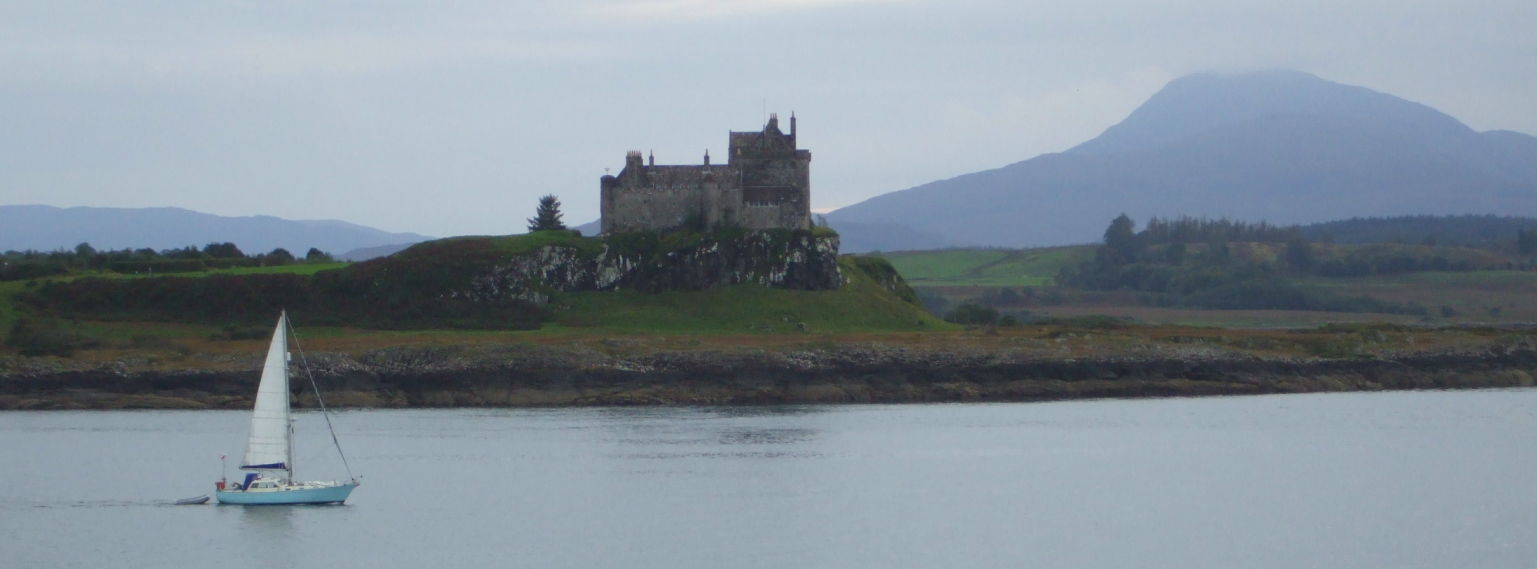
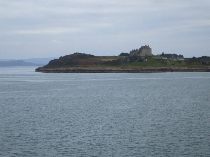
Duart Castle is at the southeast tip of the Isle of Mull. Duart is the ancestral home of Clan MacLean. The clan was supposedly founded by a Scots warlord named Gilleain na Tuaighe, who lived circa 1174-1249.

Duart Castle, home of Clan MacLean.

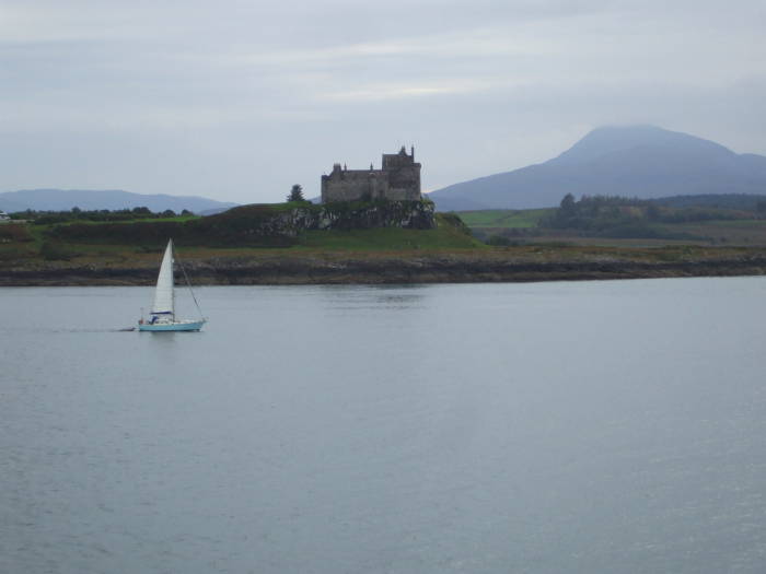
There has probably been a fortress on this site of Dubh-Aird or Black Height since early medieval times. The current castle was probably built around 1250. The Great Keep of Duart was built by Lachlan about 1370. The Isle of Mull was taken over by the clan MacLean in 1493. They added to the fortifications in the middle and late 1500s and the late 1600s.

Clan Campbell took over Mull in 1681, and the MacLeans abandoned Duart in 1691.

The castle was occupied by government forces until 1751, and then it fell into ruin. It was restored in the early 20th century by Sir Fitzroy Donald MacLean. It was reopened in 1912 and has been the seat of the MacLean clan chief since then.

According to some family history from a distant relative, my mother's mother's mother's father's father's mother was a MacLean, born in 1670 on Mull. As it turns out, this is not nearly close enough a connection to simply move into the castle.

Shortly after passing Castle Duart you arrive in Craignure. From there a bus crosses the Isle of Mull from Craignure to Fionnphort in about 75 minutes. The scenery along the way can be anywhere from beautiful to invisible, depending on the weather. The single lane A849 road crosses Mull. There are just a couple of villages and a few scattered homes along the way.

The small ferry leaves Fionnphort for Iona.
  Enter a city
Check-in
Check-out
Rooms :
Child
Adult(s)

At Fionnphort you board a small ferry to cross the narrow sound to the Isle of Iona. It's just 1.5 kilometers across the sound. The ferry crosses constantly during the day, taking less than ten minutes for the crossing itself, and leaving each side every 35 minutes or so. There isn't a set schedule, it goes back and forth constantly, and until you get to the end of the day the next ferry departure will be within the next 40 minutes.

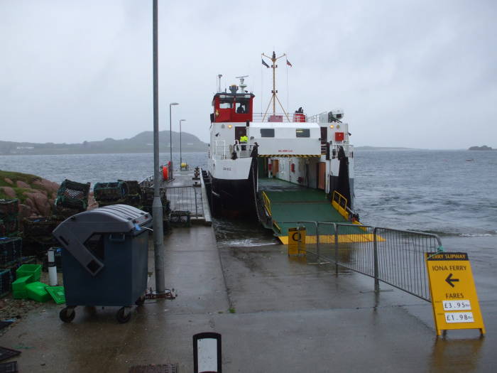
Do make a note of the bus schedule back to Craignure — the crucial connection is to get onto a bus taking you back to the ferry port at Craignure.

Oban, Mull, and Iona

Scotland and Orkney

People ascending Ben Nevis near Fort William in Scotland, the highest peak in the Scottish Highlands and in all of Britain.

An ascent of Ben Nevis, the highest mountain in Britain, overlooking Glen Nevis just outside Fort William.

The Road to the Isles, over 22 miles (37 km) overland across the high Scottish moors of Lochaber from Corrour Station to Fort William.

The Road to the Isles, over 22 miles (37 km) overland across the high Scottish moors of Lochaber from Corrour Station to Fort William.

Crossing a 3-wire bridge while trekking through Glen Nevis and the Water of Nevis.

A trek through Glen Nevis and the Water of Nevis.

The Brealach Walk out of Pitlochry though the Highlands past megaliths.

The Brealach Walk out of Pitlochry though the southern Highlands and past some megaliths.

Neolithic dwellings exposed on the beach at Skara Brae in Orkney.

Skara Brae, a Neolithic village on Orkney.

Neolithic Orkney: Maeshowe, the Ring of Brodgar, the Stones of Stenness, the Knowe of Onston.

Neolithic Orkney: Maeshowe, the Ring of Brodgar, the Stones of Stenness, and the Knowe of Onston.

Geos and freestanding stone pillars along the sea cliffs of the west coast of Orkney.

West Coast Walk along the sea cliffs of Orkney's Mainland Coast.

Scapa Flow and World War II naval fortifications in Orkney.

Scapa Flow and the Churchill Barriers.

The sousterrain, an underground Pict dwelling in Orkney.

The Sousterrain, an underground Pictish dwelling in Orkney.

Church yard on the Isle of Iona in the Inner Hebrides islands off the coast of Scotland.

The Isle of Iona, and Oban and Mull.

Grit box on Orkney. Grit box on Orkney.

The Grit Boxes of Scotland.

Ordnance Survey map of the peak of Ben Nevis.

Navigating with the UK National Grid system and Ordnance Survey maps.

England

Walking along the central section of Hadrian's Wall in Northumberland.

Walking along Hadrian's Wall in Northumberland.

Stonehenge.

Stonehenge, Woodhenge, and Durrington Walls.

Avebury.

Avebury, with its stone circles, Silbury Hill, the West Kennet Long Barrow, the Avenue and numerous tumuli, a much better collection of megaliths and structures than Stonehenge!

The Eagle and Child pub at Oxford, where C.S. Lewis, J.R.R. Tolkien, and the rest of the 'Inklings' gathered to discuss literature.

C.S. Lewis and J.R.R. Tolkien at Oxford.

World War II and Cold War tunnels in the White Cliffs above Dover.

Dover's tunnels in the White Cliffs from World War II through the Cold War.

The Chain Home World War II radar towers at Swingate outside Dover.

The Swingate Chain Home radar station near Dover.

The World War II glider base near Harwell, south of Oxford.

The World War II glider base near Harwell, south of Oxford.

Bletchley Park, the Allied cryptanalysis center outside London during World War II.

Bletchley Park, the secret installation where the British broke the German codes during World War II.

The Cabinet War Rooms in London.

The Cabinet War Rooms, Churchill's emergency World War II government center underground in central London.

Lee Ho Fook's restaurant in Chinatown, made famous by Warren Zevon's 'Werewolves of London'.

You could go to Lee Ho Fook's and get a big dish of beef chow mein.

Stainless steel urinal in a pub in London.

What's the plumbing like?

Travel in the U.K. — places to stay, how to get around

My general travel page

Click here to inquire about advertising on this or any page on this site.
Home Unix/Linux Networking Cybersecurity Travel Technical Radio Site Map Contact


Use /bin/vi! Manipulate images with ImageMagick! Hosted on OpenBSD
Hosted on Apache This site is viewable with any browser Valid XHTML 1.0! Valid CSS!
© Bob Cromwell May 2012. Created with /bin/vi and ImageMagick, hosted on OpenBSD with Apache.    Root password available here, privacy policy here.